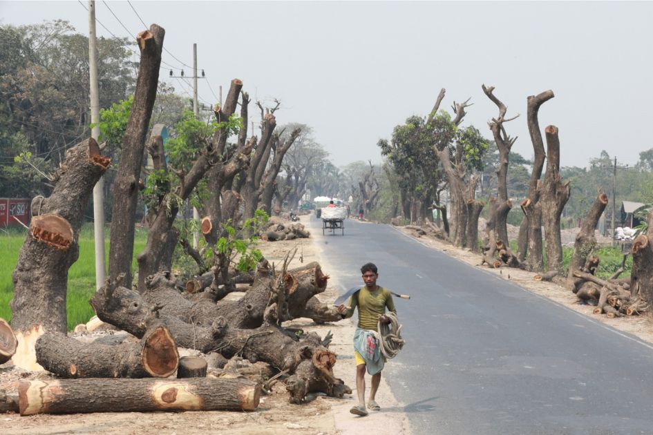



Satellite data show Chattogram lost about 260,000 hectares of tree cover from 2001 to 2025 as farming, infrastructure, industry and urban expansion reshaped Bangladesh’s most forested region.
Bangladesh lost about 270,000 hectares of tree cover between 2001 and 2025, an area of roughly 2,700 square kilometres. Almost all of that recorded loss was concentrated in the country’s southeast.
The Global Nature Watch Bangladesh dashboard says Chattogram Division accounted for 94% of the national total, losing about 260,000 hectares over the 25 years. Sylhet was a distant second with around 9,000 hectares, followed by Mymensingh with 3,400 hectares and Dhaka with 2,900 hectares. The divisional values are rounded, so they should not be added together to reconstruct the national total.
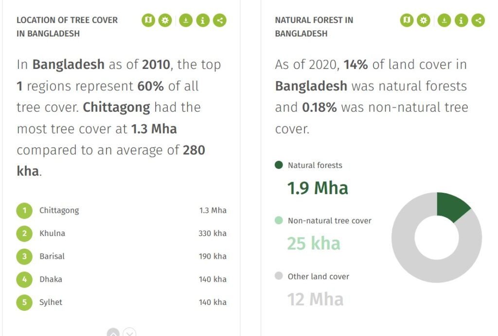
The concentration makes Chattogram the centre of Bangladesh’s tree-cover crisis. The division contains the Chittagong Hill Tracts, the forested landscapes of Cox’s Bazar, coastal mangroves, plantations, orchards and the country’s second-largest city. It is also a zone of rapid industrial, transport, tourism and settlement growth.
The latest annual data underline that the pressure is not only historical. The Global Nature Watch Chittagong Division dashboard estimates that the division held about 1.2 million hectares of natural forest in 2020, covering around 40% of its land area. In 2025 alone, it recorded about 13,000 hectares of natural-forest tree-cover loss, associated with an estimated 7.5 million tonnes of carbon-dioxide-equivalent emissions.
Those numbers are a warning, but they are not a complete measure of deforestation. The distinction is essential to understanding what the satellite record proves, what it suggests and what Bangladesh still needs to verify on the ground.
A national number with a regional centre
Global Nature Watch, known as Global Forest Watch until an official name change on 1 July 2026, uses satellite-based data developed through the University of Maryland and made available by the World Resources Institute. Its long-term dataset maps complete removal of tree canopy within approximately 30-metre pixels.
At the default threshold, tree cover means vegetation taller than five metres with canopy density above 30% in the year 2000. That definition includes natural forests, timber plantations, rubber stands and other tree crops. It can detect a stand-replacement disturbance, but it does not by itself reveal what the land became afterward.
The World Resources Institute’s explanation of the annual data is explicit: tree-cover loss can result from permanent conversion, plantation harvesting, logging, fire, storms, landslides, disease or other disturbances. The dataset records gross loss and does not subtract tree-cover gain. It also records only the first detected loss event in a pixel after 2000, so repeated clearing of the same plot is not counted as a new loss every time.
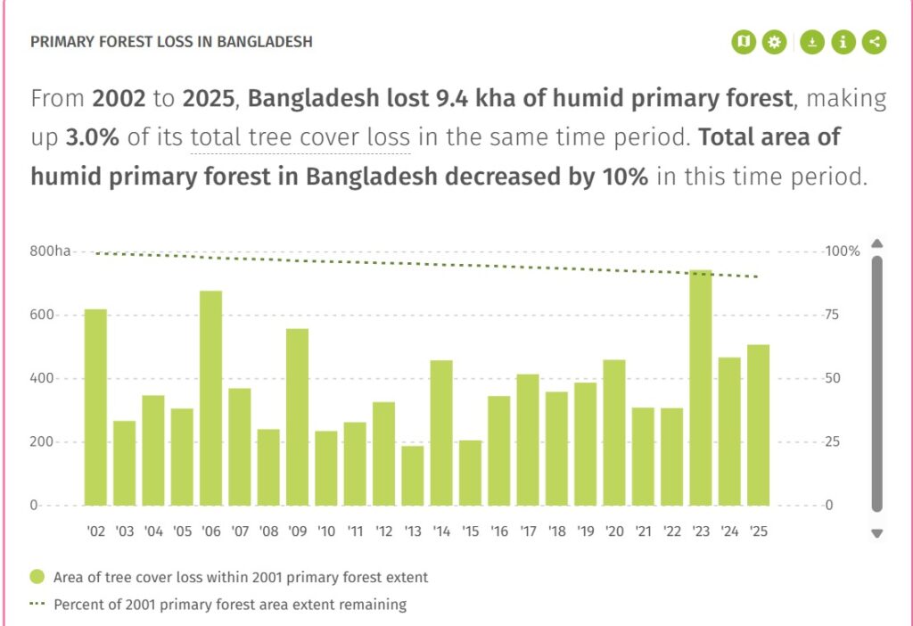
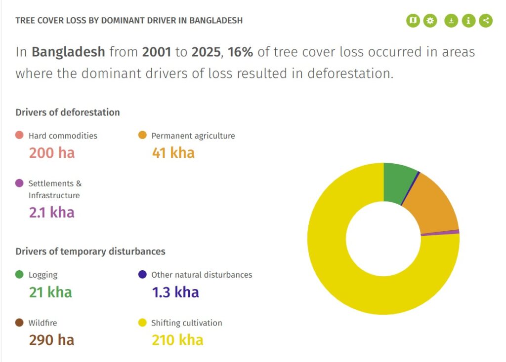
Deforestation is narrower. It generally means human-caused, permanent conversion of natural forest to another land use. According to the national dashboard, 16% of Bangladesh’s tree-cover loss occurred in areas where the dominant driver is classified as one that results in deforestation. That does not establish that every pixel in the remaining 84% fully recovered, nor does it make temporary clearing ecologically harmless.
The driver model has another important limitation. As the Global Forest Review methodology explains, it assigns the dominant driver at a one-kilometre scale across the full 2001-2025 period. It cannot identify the exact cause of every 30-metre loss pixel or show how the dominant cause changed from year to year. Field investigation and finer land-use records are still required.
Even with those cautions, the regional pattern is unmistakable. Rounded district figures on Global Nature Watch show about 120,000 hectares of tree-cover loss in Bandarban, 83,000 hectares in Rangamati, 36,000 hectares in Khagrachhari, 13,000 hectares in Chittagong district and 11,000 hectares in Cox’s Bazar since 2001. Because each figure is rounded independently, their sum will not precisely match the divisional total.
Shifting cultivation dominates the model
The driver dataset associates about 210,000 hectares of Chattogram’s recorded loss with shifting cultivation, locally known as jhum. That makes it the largest modelled driver by a wide margin, but the classification needs social as well as technical context.
Jhum is a traditional livelihood and food-production system in the Chittagong Hill Tracts. Farmers clear a plot, cultivate mixed crops and then leave the land fallow so soil and vegetation can recover. Where fallow periods remain long and land access is secure, the system can operate as a rotation rather than permanent conversion.
The problem is the compression of that cycle. The World Bank’s PROGREEN programme says roughly 60,000 households, or 18% of households in the hill tracts, practise jhum. Fallow periods that historically lasted 10 to 15 years now average about three years and are sometimes shorter. Less recovery time can reduce soil fertility, accelerate erosion and prevent secondary vegetation from regaining the structure and ecological functions of older forest.
Veteran forest researcher Professor Mohammed Kamal Hossain said the satellite estimates were broadly reliable and any margin of error was unlikely to change the overall picture. Development projects, settlements, forestland transfers, encroachment, salt production and infrastructure had all contributed to loss across the division, he said in the original reporting.
Mihir Kumar Doe, then Chattogram Circle Conservator of Forest, said Khagrachhari, Rangamati and Bandarban contained substantial forest resources, but large areas were classed as unclassed state forest and were outside the Forest Department’s direct control. Indigenous communities practised jhum and also converted some land to other crops, he said.
That governance structure makes a simple ban on jhum both unjust and unlikely to work. Conservation measures need to recognise customary land use, traditional knowledge and Indigenous rights, while expanding viable livelihoods that reduce pressure for frequent clearing. PROGREEN’s landscape-planning approach similarly calls for negotiated land-use choices, biodiversity protection, clear benefit-sharing and community participation rather than a single tree-planting target.
Industrial expansion tests the meaning of protection
The hill tracts are not the only pressure point. In Mirsarai and neighbouring coastal areas, industrial development has transformed land that once functioned as a protective green belt.
A 2025 investigation by The Climate Watch and parallel reporting by The Business Standard, citing Forest Department records and officials, found that more than 55 million trees had been cleared since 2015 for the Mirsarai Economic Zone, now the National Special Economic Zone. The reporting said the project occupied 22,335 acres recorded as reserved forest, including 853 acres of coastal mangrove forest.
Those figures differ from the draft’s earlier estimate of 50 million trees and 2,400 acres of mangrove. The revised numbers are stronger because their provenance is stated. They should still be presented as Forest Department-based reporting, not as a direct output of the Global Nature Watch satellite model.
The environmental consequences extend beyond the number of trees removed. Coastal mangroves slow wind and waves, trap sediment, provide nursery habitat for fish and help protect settlements from cyclones and tidal surges. Converting them to roads, factories and utilities changes the land’s function even if new trees are planted elsewhere.
There is also an unresolved question over land that was allocated but not used. Bonik Barta reported that the Forest Department sought the return of about 4,104 acres of densely vegetated land on the southwestern edge of the zone so it could be protected and restored. That proposal offers a practical test of whether land no longer required for industry can be returned to ecological use before further degradation occurs.
The legal standard has changed since many of these projects were conceived. Parliament retained the Forest and Tree Conservation Act, 2026 after the measure was first promulgated as an ordinance. Its core provisions bar the use of natural forest for non-forest purposes. Other forest land may be diverted only for unavoidable national needs when no alternative exists, with high-level approval, independent environmental and social assessment, consideration of ecosystem and species risks and compensatory afforestation.
A law, however, cannot restore a converted landscape by itself. Its significance will depend on whether forest boundaries are publicly mapped, alternatives are genuinely assessed and violations by public agencies receive the same scrutiny as private encroachment.
Cox’s Bazar: camps, roads and shrinking corridors
Cox’s Bazar shows how humanitarian need, long-running encroachment, infrastructure, tourism and wildlife conservation can collide in the same landscape.
Bangladesh was hosting about 1.2 million Rohingya refugees in 2026, most of them in camps in Cox’s Bazar, according to a June briefing by the UN refugee agency. The major influx that began in 2017 required shelter and services on an extraordinary scale. Land was cleared for camps, roads and facilities, while early dependence on firewood placed further pressure on nearby forests.
A UN programme assessment says more than 7,000 hectares of forest in refugee and host-community areas were extremely damaged or lost after the influx. That figure should not be used to assign blame to refugees alone. The crisis was created by forced displacement, the location and design of emergency settlements, pre-existing degradation and the initial absence of cleaner household energy at sufficient scale.
Later interventions show that pressure can be reduced. A 2024 SAFE+2 programme report recorded rehabilitation of 578 hectares of degraded forestland in the camps and surrounding forest divisions. The shift to liquefied petroleum gas also sharply reduced reliance on firewood, although long-term financing remains essential.
Doe said the influx caused extensive forest destruction as land was cleared for settlements and associated facilities, while longstanding encroachment was another major source of degradation. Professor Kamal also pointed to state land transfers and the loss of habitat along elephant movement routes between Naikhongchhari, Paneshra and Himchhari.
The Chattogram-Cox’s Bazar railway illustrates both the damage risk and the limits of mitigation. The Asian Development Bank says the route passes through several elephant corridors and the Chunati and Fasiakhali wildlife sanctuaries and Medhkachapia National Park. An IUCN connectivity case study says 27 kilometres of the 103-kilometre alignment cut through the three protected areas.
The project incorporated an elephant overpass, two underpasses, fencing and habitat improvements. Those measures are important, but they do not erase the wider effect of a new transport corridor. Railways and roads can fragment habitat, alter drainage, increase noise and make previously remote forest edges easier to access. Their success must therefore be judged by long-term wildlife monitoring, not only by whether crossing structures were constructed.
The older footprint of development
Chattogram’s landscape transformation began long before today’s economic zones and transport projects. The Kaptai hydroelectric scheme, completed in the early 1960s, inundated forest, homes and some of the most productive agricultural land in the Chittagong Hill Tracts.
A United Nations background paper records that around 100,000 people were displaced, many of them Indigenous. The reservoir brought electricity and other economic benefits, but it also removed land, disrupted communities and altered the ecology of a vast watershed. Its legacy remains central to any discussion of development and consent in the hill tracts.
Road building, state settlement programmes, commercial plantations and agricultural expansion subsequently changed land use across the region. The cumulative impact matters. A single project assessment may describe one road, one industrial estate or one settlement, while the forest experiences their combined footprint as fragmentation, new access, edge effects and repeated disturbance.
The city loses its hills and green spaces
Urban Chattogram presents a different but connected form of loss. The original draft said more than 200 hills had been levelled in 25 years. The available research supports a different formulation.
A University of Chittagong study said the city had more than 200 hills in the early 20th century and lost more than 120 over about four decades. The remaining hills were divided into intact, moderately threatened, highly threatened and extinct categories. Later reporting by The Climate Watch used the same approximate figure of 120 lost hills.
The city’s broader green decline is also measurable. A peer-reviewed Land Use Policy study found that green-space coverage fell from 68.34% in 1990 to 36.51% in 2020. About 51.32 square kilometres of green space were converted to built-up land, with the greatest losses at low to moderate elevations and on gentler slopes.
Dr Iqbal Sarwar, a professor of geography and environmental studies at the University of Chittagong, said the port city had been predominantly hilly and forested about five decades ago. ‘As the city expanded, many of its hills disappeared. This has been one of the major drivers of tree-cover loss in the city,’ he said.
The human cost becomes most visible during extreme rain. The Climate Watch reported that 412 millimetres fell in Chattogram in 24 hours in July 2026, the highest such total in 43 years, as landslides killed 29 people across Chattogram, Rangamati and Cox’s Bazar. Heavy rain is the trigger, but hill cutting, deforestation, unsafe settlement and blocked drainage shape who and what is exposed.
Green does not always mean forest
Dr Md Aktar Hossain, director of the Institute of Forestry and Environmental Sciences at the University of Chittagong, said the scale of Chattogram’s recorded loss partly reflected the division’s starting geography. Much of the region was historically covered by hills and forests, so clearing there produces a larger satellite signal than in less wooded divisions.
He said cleared land was often converted to ginger, turmeric, paddy, vegetables, cassava and dragon fruit, or to mango, rambutan, jackfruit and rubber plantations. Those land uses may remain green in a satellite image. They are not, however, ecologically equivalent to natural forest.
Natural forests contain multiple layers of native vegetation, dead wood, soil organisms and connected habitat that develop over time. A commercial orchard or even-aged plantation may store carbon and provide income, but it generally supports a narrower range of species and different water, soil and habitat functions.
Aktar estimated that the area affected by forest-cover loss could be around 200,000 hectares, while stressing that the figure included land now occupied by plantations and orchards. His estimate and the 260,000-hectare satellite total measure related but not identical things. Neither should be described as 260,000 hectares of permanently destroyed natural forest.
The ecological stakes are nevertheless high. The Global Forest Review’s soil and water assessment notes that tree cover stabilises soil and reduces erosion. Loss on steep, erodible slopes under intense rainfall can degrade water quality, fill waterways and reservoirs with sediment and increase landslide risk. In Chattogram, those processes interact with wetland filling, drainage obstruction and dense construction.
The carbon signal is also substantial. Global Nature Watch associates Bangladesh’s 2001-2025 tree-cover loss with about 160 million tonnes of CO2e emissions, around 150 million tonnes of it in Chattogram Division. These are modelled gross emissions linked to recorded loss, not proof that every hectare was permanently deforested or that subsequent regrowth stored no carbon.
Planting alone will not close the gap
The government has responded with both legal reform and a large planting pledge. Environment Minister Abdul Awal Mintoo said the country would plant 250 million trees over five years under the National Green Mission. Doe said proper implementation could compensate for much of what had been lost.
Bangladesh’s third nationally determined contribution, submitted under the Paris Agreement, also sets a 2035 goal of afforestation and reforestation across 100,000 hectares of coastal areas, islands and degraded land. It identifies 20% of the target as unconditional and 80% as dependent on international support.
There are early restoration examples. A government progress account said 5,093 acres of forest land were reclaimed and afforested between August 2024 and June 2025, while a programme in Chunati began replacing invasive acacia with native species over a much larger planned area. Such work is more ecologically meaningful when it restores native composition and connectivity rather than simply increasing the number of planted stems.
Professor Iqbal said protecting existing forests should remain the priority. Planting programmes need years of maintenance, protection and transparent survival monitoring, he said. Pressure from settlements on hills and dependence on forest resources must also be addressed.
The warning is simple: a seedling is not an instant forest. Plantation targets can be met on paper while mature natural forest continues to disappear. Survival rates, species selection, land tenure, ecological suitability and protection after planting determine whether a campaign creates a functioning ecosystem or a short-lived statistic.
The unanswered questions in the data
Bangladesh needs to move beyond a single measure of green cover. Natural forest, commercial plantation, orchard, agroforestry, regenerated woodland and urban vegetation should be mapped separately. Permanent conversion should be distinguished from rotational clearing, plantation harvest and storm damage.
The Bangladesh Forest Inventory provides a national framework, while satellite platforms offer frequent and consistent observation. The missing link is a public system that connects those datasets to parcel-level land records, environmental clearances, forest transfers, restoration sites and field verification.
Four disclosures would immediately improve accountability: an annual map of natural-forest conversion; a public register of forest land transferred or proposed for non-forest use; project-by-project cumulative impact assessments; and survival and biodiversity results for government planting programmes. In the hill tracts, data collection should be developed with Indigenous communities and recognise customary tenure rather than treating lived landscapes as administratively empty land.
The central unanswered question is how much of Chattogram’s 260,000 hectares represents temporary disturbance, how much has regenerated, how much has shifted to plantations or orchards and how much natural forest has been permanently converted. The new natural-forest layer improves analysis from 2021 onward, but it cannot reconstruct every land-use transition since 2001.
That uncertainty is a reason for better investigation, not for dismissing the satellite warning. Chattogram is Bangladesh’s economic powerhouse, yet its hills, forests and coastal vegetation are also infrastructure. They hold soil, regulate water, shelter wildlife and reduce exposure to cyclones, tidal surges, floods and landslides.
The 94% figure therefore poses a development question as much as a forestry question. Bangladesh can plant millions of trees, but it cannot recreate mature forest functions on demand after industrial estates, transport corridors, settlements and farms have permanently changed the land.
The task is not simply to make Chattogram look green from space. It is to protect the natural forests that remain, restore ecological connections where they have been broken, and ensure that future development accounts for the full value of the landscapes on which the region’s economy and people depend.
This story is published as part of the CPRD–TCW Reporting Fellowship 2025