At the rate climate change is progressing now, 19 coastal districts will soon disappear into the sea, and will be completely erased from the map of Bangladesh
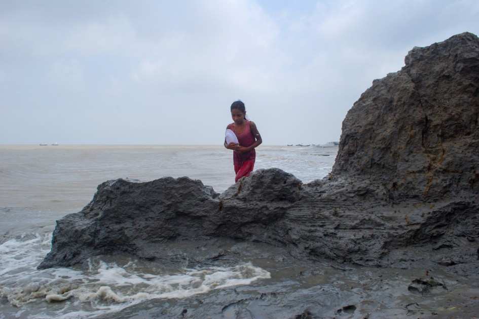
For the people living in 19 coastal districts across Bangladesh, erosion destroying their lives and livelihoods in an instant is a grim reality. Every monsoon, survivors living near the seashore roll the dice and await their fate.
The fear of losing farmland and homestead due to coastal erosion is a constant threat. In the last five decades, Bangladesh’s coastal populace lost at least 125,000 hectares of land. Many of them turned into climate refugees after losing their homes or cropland.
While many have taken refuge in other chars and embankments, a significant portion of the climate migrants have taken refuge in metropolitan cities across the country. They had to start their lives entirely from scratch.
Even in the sixties, many lived in char areas on different coastal islands, such as Hatia, Sandwip, Bhola, and Monpura. During that period, agriculture, fishing, and cattle rearing used to be the livelihoods of these coastal residents.
When the sea began to swallow up the coast, some residents tried to establish new settlements some distance away from the sea. But they could not outrun the sea. Erosion gradually caught up with the new settlements as well.

After repeatedly losing everything, they gave up and fled to big cities. It is all too common on the coast for many wealthy families to lose all their property and farmland in a catastrophic flood or cyclone during the monsoon season and become completely penniless.
Woes of Sandwip
The Center for Environmental and Geographic Information Services (CEGIS) of Bangladesh has been keeping records of land loss to the sea and rivers since 1973.
According to CEGIS data, from 1973 to 2020, around 71.15 square kilometers of land in Sandwip Upazila – the only island upazila in Chattogram – disappeared into the sea.
Sandwip was once a rich settlement, frequented by Portuguese and Arab merchants. The island had shipbuilding and salt production industries. It has completely abandoned agriculture and trade. Sandwip now depends solely on expatriates for income.
Although the island currently has a population of 300,000, Sandwip natives more than twice that figure currently live and work across the country, including in Chattogram. The most frequent cases of people leaving this island are due to the sea swallowing up land.
According to the Internal Displacement Monitoring Center, several thousand people in Bangladesh are losing their homes and land every year due to the rising sea levels caused by climate change.
According to a study by Dhaka University and the California Institute of Technology (Caltech), the area of Sandwip was 502 square kilometers in 1880. Due to extreme erosion, the island area decreased to 290 square kilometers.
So, around 40% of Sandwip disappeared into the sea between 1984 and 2007.
Former upazila nirbahi officer (UNO) of Sandwip Upazila, Samrat Khisa told The Climate Watch, “Erosion by the sea has become the natural fate of Sandwip. Once a very big island, it has now come down to about 258 square kilometers.
“Every year, fresh areas are eroding away. Along with their homes, people are losing their croplands. Many residents are moving to Chattogram or different parts of the country.”
Samrat added, “There was initially a rush to move from Sandwip to the char areas of Noakhali. Nowadays, people from here are moving to different upazilas of Chattogram or the hill tracts.”
The Sandwip Agriculture Department does not have accurate data on how many farmers have lost cultivable land. According to the Bangladesh Bureau of Statistics (BBS), Sandwip’s population under the 2001 census was 0.33 million in 2001. The population decreased to 0.27 million in 2011.
The latest census, however, shows that the population of Sandwip has increased slightly to around 0.3 million, but the number of people who left the island during this period is large.

Just like Sandwip, erosion and its life changing impacts are a harsh reality for the 19 coastal districts across Bangladesh. Every year, some upazilas or villages in those districts disappear into the sea or coastal rivers forever because of erosion.
In addition to being displaced, the people here are losing their agricultural land, one of the key sources of their livelihood. Many are becoming homeless. According to CEGIS data, at least 2,640 hectares of coastal land are disappearing into the sea every year.
In the 47 years from 1973 to 2020, around 13,997 hectares of land disappeared into the river in Hatia upazila of Noakhali district. Similarly, 9,479 hectares were lost in Bhola Sadar upazila, 8,299 hectares in Mehendiganj upazila, and 7,279 hectares in Hijla upazila of Barishal.
In total, more than 99,385 hectares of agricultural land have been lost in the 21 upazilas during this timeframe.
Muzaffar Ahmed, a resident of Sandwip, said, “Coastal erosion intensified after the catastrophic flood of November 1970. When the erosion approached our homestead, our family was forced to move elsewhere.
“At that time, land worth about Tk1 million was lost to the erosion, leaving our family penniless. The members of our family abandoned agriculture and chose to earn a living through small businesses. Many of our family members left for the Sitakunda area to establish new settlements.”
Kutubdia, Hatia faring no better
Kutubdia is another island upazila situated on the shores of the Bay of Bengal. Among residents, 80% depend on agriculture. Due to the gradual rise in sea level, at least 60% of this island has disappeared into the river in the last 60 years.
The Hatia Upazila of Noakhali district is faring no better.
Mohammad Minhaj Uddin, a local resident, shared his harrowing experience. After his higher secondary certificate (HSC) examination in 1997, he went to visit his relatives in Chattogram for a month.
At that time, many areas of the country had no telephone coverage. Returning home after a month, he got off the steamer and set off for his home in the then Mofizia area under Sukhchar Union.
When Minhaj told a rickshaw puller his home address, he learned that his home, and his entire neighborhood had disappeared into the sea. His family barely survived the ordeal.
After searching for some time, Minhaj found his family, now penniless, in the Khaserhat area under Charking Union, around 20 kilometers away from the sea. Though the family built a new home in Khaserhat, they are still afraid that the sea will once again take everything they have.
Residents and experts blame the increase in sea level driven by climate change, and the resulting tidal surges in monsoon, as the reason behind the shrinking of Kutubdia Island.
According to the Coast Trust, a non-governmental organization that has been working in Kutubdia upazila for years, the sea has swallowed up many areas of Kutubdia in the last few decades. The organization obtained this data after analyzing satellite images.
‘Erased from map of Bangladesh’
A study by the SAARC Meteorological Research Center (SMRC) has shown that sea level is rising in coastal areas of Bangladesh.
The SMRC study, which measured the tidal height of 22 years, found that sea level is rising by 0.78 centimeters in Cox’s Bazar, 0.6 centimeters in Char Changa and 0.4 centimeters in Hiran Point every year.
A recent study has shown that 12.34% to 17.95% of coastal land could be submerged due to sea level rise in the coming years. The government had conducted this study under the title of “Climate Change Initiative of Bangladesh.”
At least 10% of the land in 14 upazilas of Chattogram has disappeared into the sea in the last two decades. By 2050, one in seven people in Bangladesh will be displaced due to climate change. If the sea level rises by 19.6 inches (50 cm), Bangladesh could lose about 11% of its landmass.
At a recent event, advisor to the Ministry of Environment, Forests and Climate Change Syeda Rizwana Hasan said, “At the rate climate change is progressing now, 19 coastal districts will soon disappear into the sea. They will be completely erased from the map of Bangladesh.”
Climate migration across the country has become more and more common in recent years.
Nader Ali Bepari, a resident of Kalupura Char in Bhola, along with many residents of Gazipura and many other char areas, have settled in district Sadar Upazila after the river washed away their homes and farmland.
They were self-sufficient farmers, able to feed themselves throughout the year with crops from their own lands. Now they are trying to survive on a few decimals of farmland and makeshift small huts.
Many gave up on farming entirely and now work in different factories in Dhaka. Some char residents have set up small shops near river docks.
Food grain imports skyrocketing
As farmland for cultivating paddy decreased over the years, Bangladesh is forced to boost imports every year to cover the needs of its growing population. Once self-sufficient in food grain production, the country has increased such imports due to the coastal erosion of croplands.
According to a 2001 census, the population of Bangladesh was around 130 million. The latest 2022 census shows that the population of Bangladesh has increased by 23% to 160 million.
According to the National Board of Revenue (NBR), the import of rice – Bangladesh’s staple food grain – has increased by 78% in the last 20 years. Due to the increase in sea level salinity, rice production in coastal districts is decreasing by about 5.8% to 9.1% annually.
NBR data shows that the country imported only 126,000 tonnes of rice in fiscal year 2001-02. This figure reached 1,359,100 tonnes in FY2020-21. Government estimates show that rice imports for FY25 may exceed 1.5 million tonnes.
Due to the decline in agricultural land, and the gradual decrease of paddy production from coastal districts, Bangladesh’s dependence on rice imports is rising alarmingly.
Farmer Maqbul Fakir, a 64-year-old resident of Lamchhari village in Barishal, said, “In a span of two years, I lost 21 acres of land to Kirtankhola river erosion. My farmland used to produce 7 to 8 maunds of paddy annually.
“Currently, I have bought a few acres of land on the other side of the village and settled there. I can now barely cover the cost of my family’s day-to-day expenses. I am running a small shop on the village roadside.”
Ex-additional director of Chattogram region’s Department of Agriculture, Md Mofazzal Karim said, “The coastal districts are shrinking because of the ongoing sea and river erosion. The people in coastal regions are being displaced and losing their agricultural land constantly.
“Even if new char areas rise in some places, it takes at least 20 years to establish new settlements there and make the land suitable for agriculture. It takes generations to bring the char land under ownership. Life in the char areas was never easy. But now it has become nearly hopeless.”
Major economic impact
Of the 64 districts, 19 are coastal in Bangladesh. Under the Chattogram division, 6 districts – Feni, Noakhali, Chandpur, Lakshmipur, Cox’s Bazar, and Chattogram are coastal. Under the Barishal division, Jhalakathi, Barishal, Patuakhali, Pirojpur, Bhola, Barguna are coastal. In Khulna division, Khulna, Satkhira, and Bagerhat are coastal districts.
Sandwip River Erosion Rehabilitation Association President Shibbir Ahmed Talukder said, “All these districts are losing agricultural land to erosion. And the phenomenon is showing no sign of slowing down.
“New areas are eroding every year. In the past few decades, Sandwip had a population of 0.4 million, but now it has come down from 0.3 million. There is not enough land here for rice cultivation. Erosion has taken a lot of farmlands from the islanders.”
He continued, “So residents are now turning to fishing and other professions. Many left Sandwip to establish new cluster villages and hilly areas of different districts.”
Once, nearly 25% of the country’s main agricultural crop rice came from coastal districts. Gradual erosion triggered by the rising seas level has cut down the crop yield in these regions by nearly one third.

As a result, Bangladesh is steadily losing food security due to the decline in crop cultivation and low rice production. The market price in Bangladesh used to be stable because the country was self-sufficient in terms of grain production.
Rice prices have now become far more volatile in recent years.
Coast Trust Managing Director Rezaul Karim Chowdhury said, “Erosion of coastal areas is increasing due to climate change, specifically the rise in sea level. Not only do coastal villagers are losing their homes, but they are also losing agricultural land – the only source of their income.
“So, erosion has emerged as one of the key factors behind the decline in Bangladesh’s crop production.”
Five decades ago, there were 60 mouzas in Sandwip Upazila. Over the years, 31 mouzas on the island have disappeared. Among the existing 29 mouzas, 6 have lost 20% to 80% of their landmass.